Karetu Bridge to White Gorge
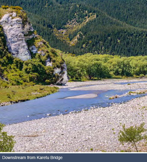
Karetu Bridge crosses the Waipara River South Branch between Ram Paddock Road and MacDonald Downs Road approximately 800 metres upstream from the confluence with the Waipara River North Branch. A short distance downstream of the confluence is Ohuriawa Gorge, a geologically distinctive feature of the Waipara River. The gorge cuts through the southern extremity of the sandstone Doctors Hills. The inner gorge is 100-120 metres deep, steep-sided and clad in regenerating shrubland of which exotic species are dominant. The surrounding hillsides consist of unimproved pasture, reverting shrubland and pine forestry. The river is single threaded, with a gravel bed and periodic rock outcrops. The banks are lined with willows. The Gorge is considered to have high natural character due to the combination of active geological processes that have created the Gorge, the active regeneration of shrubland on the valley sides, and the invisibility from river level of any structures or other obvious signs of human activity. Ohuriawa Gorge is accessible only via the riverbed from the road bridge on MacDonald Downs Road across the South Branch one kilometre upstream, or from the Laidmore Road ford one kilometre downstream. This part of the river is subject to AMF rights and as such there is no public access to the river unless by prior arrangement and approval with the relevant landowners.
Between Ohuriawa Gorge and White Gorge the river flows for about three kilometres through a depression that marks more erodible Cretaceous formations. The White Gorge area is one of unique and internationally renowned geological significance. It contains the only exposed, continuous geological sequence from the Cretaceous to the Miocene and many examples of fossilised material from the Mesozoic and Paleogene (previouslty known as the Tertiary) Periods. It is one of the few sites where the Cretaceous – Paleogene (K-Pg) boundary is exposed. The landscape is interesting with a mix of limestone escarpments, alluvial terraces and tightly meandering, gravel-bedded river that periodically cuts into steep rocky bluffs and cliffs. Much of the Gorge and surrounding area forms part of the Weka Pass Outstanding Landscape unit as identified in the District Plan. The only access to this part of the river is via the Laidmore Road ford. This part of the river is also subject to AMF rights and as such there is no public access to the river unless by prior arrangement and consent of the relevant landowners.
The main contention of landowners is that they seek proper respect for their private freehold property and that if members of the public want to access their property then they should ask the landowner for their permission. Landowners in this section of the river have a long history of cooperating with scientists, hobbyists and the general public wishing to study the geology and fossils. The issue is not so much one about access but more around the use of vehicles and the damage they cause to the bed and banks of the river in this geologically sensitive area.
There is also a long, narrow section of Crown land administered by the Department of Conservation located along the north bank of the river approximately 0.65 – 2.50 kilometres upstream from the Laidmore Road ford. The predominant land use on the northern side of the river consists of pine forestry plantation. Given the adjacent forestry plantations and Department of Conservation reserves, the community is concerned regarding the potential risk from fire and the damage that this could cause.